Preliminary site investigations
The term ‘desk study’ or ‘desktop study’ refers to a study that is carried out purely through research, rather than physical investigations, that is, it can be done sitting at a desk. Desktop studies can provide an initial understanding of a subject or situation, identify potential risks and inform the detail, scope and methodology of subsequent investigations.
On building design and construction projects, the term ‘desktop study’ is often used in relation to preliminary site investigations, referring to the process of gathering background information about site-specific characteristics that will need to be considered during planning, design and construction, or issues that may merit more detailed physical investigations, such as site surveys.
Local authorities often require that a desk study is carried out as part of the planning or building regulations approval process.
Approved Document C of the Building Regulations defines desk studies as, ‘A review of the historical, geological and environmental information about the site’ and describes it as being ‘essential’. Desk studies might also be carried out as the starting point for assessing site lines, local context (such as architectural character, landscape, and so on), archaeology (such as the risk of uncovering archaeological remains, unexploded bombs, and so on), rights of way and other easements, the likely presence of solid and liquid contaminants, site ecology, and so on.
A thorough desk study:
- Provides an initial understanding of the characteristics of an area or site.
- Provides early identification of site characteristics and potential risks so they can be more effectively managed.
- Informs the detail, scope and methodology of subsequent investigations.
- May help avoid undertaking unnecessary, expensive or intrusive investigations.
The most common sources of information that are researched as part of a desk study include:
OS maps, including historical maps can offer information about:
- Changes in potential landslide areas.
- Changes in topography, stream and river courses.
- Coastal erosion.
- Concealed mine shafts.
- Disused quarries and in-filled ponds.
- Drainage.
- Former uses of the site.
- Old clay, gravel and sand pits.
Geological maps can provide an indication of the likely ground conditions and whether, for instance, there is any risk of subsidence or shear.
Aerial photographic records and Google maps provide useful information that can help identify or confirm historical site usage, hidden foundations, changes of topography and river course, and so on.
Services records can help locate hidden services such as; electricity cables, drainage, telephone cables, and so on.
Existing client information may exist from previous investigations, estate record drawings, and so on.
Preliminary site investigations will typically be followed by more detailed physical investigations to assess areas where more information is required, or where there are particular concerns. For more information see: Site investigations.
[edit] Related articles on Designing Buildings
- Archaeology and construction.
- Building archaeology.
- Building survey.
- Development appraisal.
- Ground conditions.
- Insitu testing of soils.
- Laser scanning.
- Pre construction information.
- Site appraisal.
- Site investigation.
- Site investigation information.
- Site surveys.
- Soil report.
- Soil survey.
- Solid and liquid contaminants site risk assessments.
- Walkover survey.
Featured articles and news
What they are, how they work and why they are popular in many countries.
Plastic, recycling and its symbol
Student competition winning, M.C.Esher inspired Möbius strip design symbolising continuity within a finite entity.
Do you take the lead in a circular construction economy?
Help us develop and expand this wiki as a resource for academia and industry alike.
Warm Homes Plan Workforce Taskforce
Risks of undermining UK’s energy transition due to lack of electrotechnical industry representation, says ECA.
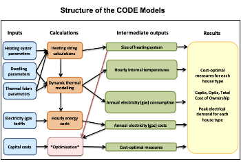
Cost Optimal Domestic Electrification CODE
Modelling retrofits only on costs that directly impact the consumer: upfront cost of equipment, energy costs and maintenance costs.
The Warm Homes Plan details released
What's new and what is not, with industry reactions.
Could AI and VR cause an increase the value of heritage?
The Orange book: 2026 Amendment 4 to BS 7671:2018
ECA welcomes IET and BSI content sign off.
How neural technologies could transform the design future
Enhancing legacy parametric engines, offering novel ways to explore solutions and generate geometry.
Key AI related terms to be aware of
With explanations from the UK government and other bodies.
From QS to further education teacher
Applying real world skills with the next generation.
A guide on how children can use LEGO to mirror real engineering processes.
Data infrastructure for next-generation materials science
Research Data Express to automate data processing and create AI-ready datasets for materials research.
Wired for the Future with ECA; powering skills and progress
ECA South Wales Business Day 2025, a day to remember.
AI for the conservation professional
A level of sophistication previously reserved for science fiction.
Biomass harvested in cycles of less than ten years.
An interview with the new CIAT President
Usman Yaqub BSc (Hons) PCIAT MFPWS.
Cost benefit model report of building safety regime in Wales
Proposed policy option costs for design and construction stage of the new building safety regime in Wales.
Do you receive our free biweekly newsletter?
If not you can sign up to receive it in your mailbox here.


